An amazing journal helps us visualize this historic journey down the Alabama River in 1814 Day two – August 12
Over the next few days, we will follow the day by day journey of the first survey of the Alabama River which started on August 11, 1814. With this journal, we will be able to visualize the sites and experience how long this historic journey took back in 1814.
(Transcription from Transactions of the Alabama Historical Society, Volume 2, 1898)
SCROLL DOWN TO READ STORY
Amazing journal helps us visualize this historic journey down the Alabama River in 1814 Day two
This valuable manuscript is first survey of the Alabama River in 1814. The trip started on August 11, 1814. Follow along their survey down the Alabama each day and see if you can determine where they are on this day.
August 12th
Proceeded at 5 O’clock A. M.
N° 60 Wt 20 ch. lands high & good on both sides
N° 80 Wt 30 ch. to a bluff on the right—good lands on both sides—best on the left.
S° 55 Wt 20 ch—along the bluff on the right—with rocky banks & Piney land—good land on the left—Small Creek on the left near the end of this distance.
S° 10 Et 40 ch. along the bluff on the right—good and high on the left—the bluff ends at this place.
S° 60 Et 40 ch. Small branch from the left at the commencement.
S° 45 Et 3 M. 40 ch.—lands good on both sides—pass to the left of an Island from 2 1/2 to 3 miles on this course—a large Impvt. on the right opposite the Island—some Improvements on the left this course ends at the upper end of a high bluff on the left on which formerly stood the Taw-wassa Indian Town—this is called Weatherfords bluff— The improvements on the right are very extensive on the bank of the river, say for 2 miles or more above & below this old Town.

South 20 ch along the bluff— This bluff has high red banks— Improvements continue on the right—Spring to the right at commencement.
S° 80 Wt 20 ch. along the bluff—This bluff is about 100 feet high its whole distance.
N° 45 Wt 40 ch. Bluff contd on left—banks mixed with yellow Ochre—Fields contd on the right—the whole of rich land on the right. Weatherfords old place of residence is on the right near the end of this distance.
N° 70 Wt 3 Miles —passed to the right of an Island at ½ to f ¾ .mt—Spring branch ¼ Mt above the island, from the right—passed the. Lower end of the lower end of the Tawwassaw Towns or Villages at 1 Mile— Here ends the bluff—passed 3 other Islands one of which is high & timbered, islands near compleat the whole of this distance— good lands to the left for the last 40 ch—lands good to the right the whole distance.
N° 45 Wt 20 ch—Improvements end at ½ . distance and bluff commences on the right & ends at a short distance—good on the left.
N° 80 Wt 60 ch. passed to the right of a small Island—good lands on both sides—Improvements on the right.
North —60 ch. passed to the right of 2 small Islands at 20 ch.— Large Improvements on the right—lands rather thin on both sides in part of this distance
N° 25 Wt 40 ch. lands good on both sides Improvt continues on the right.
N° 15 Wt 40 ch. branch from the right at 15 ch and improvements end—lands good on both sides
N° 50 Wt 20 ch—Spring on the right
S° 70 Wt 1 mile—passed to the left of an Island a large improvt opposite, on the right—rich lands on the left—A bluff on the left for half this distance
West 30 ch. To a bluff on the right, a small distance below the last named Improvt a branch to the right at the lower end of the same improvt.
S° 25 Wt 1 m 20 ch. Short bluff & rocky shore on the right— course ends at a bluff on the left—a reddish good land on the right.
S° 50 Wt 30 ch Bluff on the left & thin lands thereon— Improvt on the right
S°70 Wt 40 ch. Bluff contd on the left—Creek from the right at 15 ch lower lands on the right than on the left
S° 55 Wt I m. 40 ch. Lands good on both sides
S° 80 Wt 1 m. 20 ch. passed to the left of an Island
N° 60 Wt 20 ch. Rocky Bluff on the left good lands on the right
N° 65 Wt—20 ch. to a Bluff on the right commencing at half distance by 2 very high hills of a conical form with a narrow Valley & Spring branch between. The lower hill composed of a substance resembling red paint, like unto that used by the savages—On this Bluff is the old Indian Town called Au-tau-ga, a creek from the right above the bluff—The creek appears handsome—name not known1
Autauga Creek
S° 60 Wt 20 ch along the bluff, Improvt on rich land to the left —Autauga is a beautiful situation with valuable rich lands on the opposite shore
South 1 m. pass to the left of an Island—a valuable plantation on the left side and a large one on the right opposite and below the Town of Autauga.
S° 10 Et 1 mile a bluff on the left for the lower fourth of this distance & an Improvement.
S° 30 Wt 1 mile—passing to the left of an Island2—Passed the mouth of Cat-too-ma Creek3 from the left at 20 ch—The lands between Weatherfords bluff and this Creek are represented to be very good to the mouth of said Creek, both on, and off the river
S° 65 Wt 30 ch to an improvement on the right, on a bluff— lands good on both sides
S° 60 Wt 40 ch passed 2 good springs to the right
South 20 ch
S° 5 Et 1 M 40 chains leaving a large Island of at least 100 acres to the right—an Improvt on the Island
S° 10 Wt 40 ch to an Improvt & low bluff on the left bank, opposite the lower end of the large Island
S° 70 Wt 4 M 40 ch—Passing Path-lau-la Creek4 from the left at 20 ch and passed to the right of an Island opposite the mouth of the Creek—passed to the right of a 2d small Island— at 1 Mile below which are large Improvements on the left—lands good on both sides.
N° 65 Wt 20 ch Wm. Weatherfords plantations on the right on excellent land. Hatche-soop-ka, or Steep Creek5 empties into the river at 10 ch—This creek is sometimes called Tallawassa by the natives.
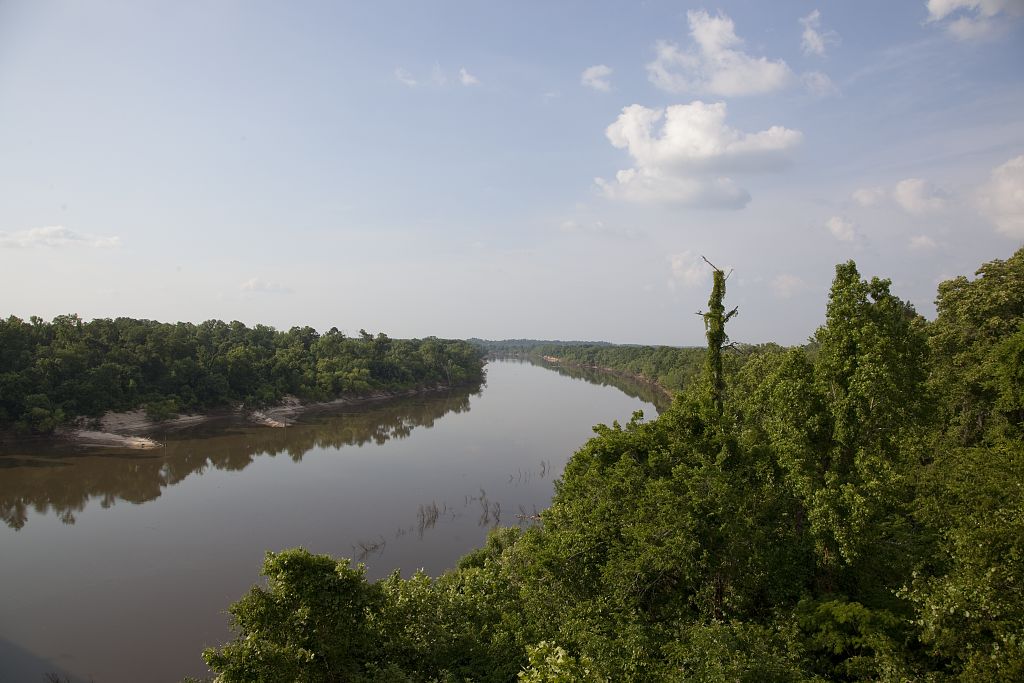
View of the Alabama River from a bridge in Claiborne, Alabama 2010 Carol Highsmith, Library of Congress
N° 30 Wt 60 ch. passed to the right of an island, plantations, or improvt continuing on the right—lands thin on the left— Improvt on the left opposite an Island—Spring on the right— landed & watered.
N° 30 Wt 40 ch. contd same course passed a fine spring to the right at 20 ch.
No 55 Wt 20 ch along a high bluff on our right, piney, and a rocky shore—lands good on the left.
West 1 mile passed 3 fine springs to the right at 20 ch—lands thin on the right, rich on the left—Rocky on the left bank at the end of this distance.
N° 65 Wt 1 mile—Passed to the right of an Island at 20 to 40 ch
S° 80 Wt 40 ch A high, handsome, Piney Bluff on the right— level, rich lands on the left—This bluff is the site of an Old Town.6
S° 30 Wt 40 ch. to the end of the bluff—spring branch at the commencement.
S° 20 Wt 30 ch good lands on both sides
N° 60 Wt 1 M 40 ch—passed to the right of an Island—Rockey bluff 20 ch on the left to the upper end of the Island—lower end timbered & improved 60 ch long—Shoal below.
N° 25 Wt 20 ch along a bluff to the left—a field on the right.
N° 10 Et 1 M 40 ch. passed to the right of an Island— an improvt on the left—Bluff on the right at the lower end of this distance
North 20 ch. and Encamped on the right bank, at the lower end of the bluff—at the distance this day of 43 miles
1Autauga Creek. Hawkins describes the neighboring village (At-taugee) as small but spread out for two miles. The inhabitants were hospitable but had little intercourse with the whites. They threw away whatever a white man left of a meal and immediately washed everything used by the guest. See Hawkins’ Sketch of Creek Country. 1798, pp. 35-7. At this point was located the town of Washington, first County seat of Autauga.
2Hadnot’s Island
3“Catoma Creek, just below Montgomery. According to Dr. W. S Wyman, in an article in the Montgomery Souvenir, 1898, the word was originally Okee-tomee. Alabama (not Creek) words meaning “Sunny Water,” or, literally, ”Water-Sunny.” It is now crossed by many railroads.
4Pintlala Creek on modern maps. The island above it is Manack’s Island, for whom the creek is also sometimes called.
5This may be the location of the Bear Fort of the French, found on a map of 1732. See map in Colonial Mobile, p. 158.
6Perhaps the site of the old village of Vernon, Autauga Co., or some point in that vicinity.
ALABAMA FOOTPRINTS – Volume I – IV: Four Volumes in One
The first four Alabama Footprints books – Volumes 1-IV have been combined into one book
- ALABAMA FOOTPRINTS Exploration
- ALABAMA FOOTPRINTS Settlement
- ALABAMA FOOTPRINTS Pioneers
- ALABAMA FOOTPRINTS Statehood