Down the Alabama River Day Eight on August 18, 1814
(Continued) This amazing journal helps us visualize this historic journey down the Alabama River on August 18, 1814 – Day Eight of the journey.
Scroll down to read story
Over the next few days, we will follow the day by day journey of the first survey of the Alabama River which started on August 11, 1814. With this journal, we will be able to visualize the sites and experience how long this historic journey took back in 1814.
(Transcription from Transactions of the Alabama Historical Society, Volume 2, 1898)
August 18, 1814
Proceeded at 40 minutes after 10 O’Clock A. M.
N°. 60 W. 30 ch—Weatherfords Improvt8. on the left, commences at the ferry, & contains a part of an excellent piece of bottom land—The improved lands, opposite, are also claimed by him—A swamp on the back part of the Improvt. on the right
N°. 85 Wt. 60 ch—A bluff commences on the right at 40 ch— Improvt. on the same side ends at 30 ch. below which & above the bluff two creeks enter from the right at 40 & 45 ch—On the bluff is a small Improvt. occupied by a Mr. Jones1 near which is a fine spring—This is an elegant situation—The road to St. Stephens runs near this Improvt.—a fine bottom on the left.
N°. 60 W. 40 ch—The bluff continues on the right & bottom on the left—The bluff contains handsome farming land but not very rich—growth, Pine, oak & Hickory.
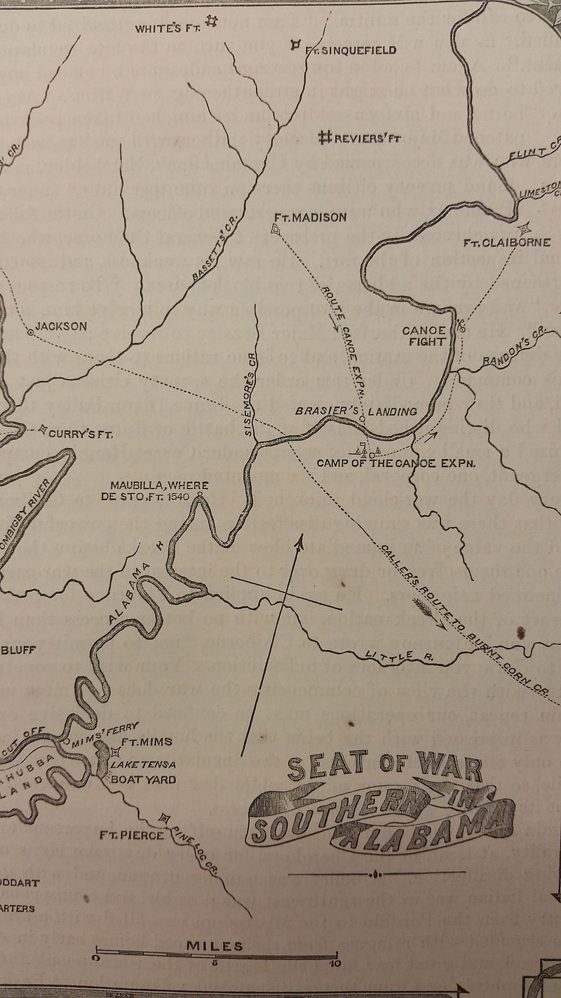
Random’s Creek can be seen on this map (Alabama Department of Archives and History)
S°. 45 W. 2 m 40 ch—Bottom on the left—Bluff ends at a short distance, and Pine hickory & oak high lands continue— At a short distance below the commencement, the lands on the left rise to a high rich upland intermixed with a few pine—at 60 ch the lands on the right descend to rich high land containing a few scattering pine
S°. 40 W. 40 ch—Good lands on both sides—bottom on the right & high lands on the left—a spring branch to the left, near the end.
S°. 60 W. 1 mile—High, Oak, hickory & pine lands on the left—Oak & Hickory bottom on the right—a spring at the left near the beginning—A creek from the right at 25 ch—lands below the creek on the left lower & without Pine and descends to rich bottom lower down.
S°. 20 W. 30 ch lands on both sides as represented in the last course above—a spring branch from the right.
S°. 60 Et. 1 m 40 ch—lands on the right rise to a bluff at 20 ch of tolerable good quality—Bottom continues on the left—passed to the left of a small Island—A large creek from the right near the lower end of this course
S°. 70 Et. 3 miles—High lands on the right & bottom on the left—Bottom on both sides from 40 ch—a creek to the left at 2 miles—another creek from the left at the end, and an Improvt. on both sides
S°. 50 Et. 40 ch—a bluff of good lands on the left—bottom on the right—a fine spring branch from the left at 20 ch
South 1 mile—High bluff on the left & a prime bottom on the right cont8. 3 Improvts.
S°. 10 Wt. 2 m. 40 ch—High, poor bluff contd. on the left— rich bottom & Improvt. on the right—Bluff on the left ends at 40 ch and is succeeded by rich bottom, an Improvt. on each side of Peter Randon’s. a friendly half-breed—these Improvts. are large and fine, that on the right the largest & contains about 100 acres—They are at the distance of about 1 mile from the commit. of this course.
S°. 40 Wt 2 m 40 ch—Lands rich and excellent on both sides— a large creek from the left at 20 ch—a spring branch from the same side at 2 miles.
S°. 30 NW. 50 ch—Prime, rich bottom lands on both sides— that on the left very low & probably swampy—a creek or Bayou from the left2
S°. 60 Wt. 1 m 20 ch—Improvt. on the right—lands on both sides as represented in last course—The Improvt. on a superb piece of land—a small creek from the left at 50: An Elegant tract of land below the creek containing a small improvt. at a good boat landing—The Improvt. on the right is said to have belonged to Dixon Baily3 a friendly half Breed chief who fell fighting bravely in defence of Fort Mimms—It is large & continues part of the next course
S°. 85 Wt. 1 mile—Prime lands continue on both sides—Creek from the left at 40 ch
S°. 60 W. 1 m 40 ch—Prime lands continue on both sides— An old Improvt. on the right at 25 ch—passed to the right of an Island—Creek from the left at 40 ch—Creek from the right near the end468
J. 70 W. 2 M 40 ch—A narrow bottom on the right bounded by a high bluff of poor pine lands—Good bottom & an Improvt. on the left, near the beginning—A creek from the right & the bottom widens.
S°. 40 W. 60 ch—an old Improvt. on the left—Encamped at a large plantation on the right at 23 M 60 ch
1Probably Josiah Jones, a militia captain, who emigrated to Clarke County about 1809 and died there in 1843.—See Ball’s Clarke County, p. 538.
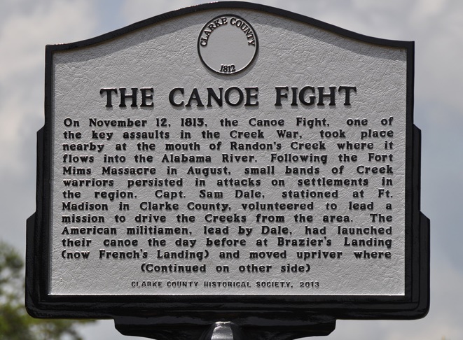
2“Randon’s Creek. Just above the mouth of this creek occured the celebrated “Canoe Fight” which Tatum does not mention, although he stopped at Claiborne just above, rested for the night just below, and passed over its scene in broad daylight. Here Sam Dale, Jerry Austin and James Smith on November 12. 1813, in a hand to hand battle in boats overcame and killed seven Indian warriors. For Bibliography of the engagement see Note 4, Halbert’s Creek War Incidents, supra.
3“For account of Dixon Baily and connections, sec Halbcrt and Ball’s Creek War, pp. 164-5. The location here referred to is indicated on old maps as Peggy Baily’s Bluff.
4In this vicinity, some five miles above Gainestown, is French Landing, by many believed to be the site of the ancient Maubila. Rev. T. H. Ball maintains this view in a paper published in Halbert and Ball’s Creek War, pp. 320-331. See Note 72, infra.
ALABAMA FOOTPRINTS – Volume I – IV: Four Volumes in One (Volume 1-4)
SAVE – BUY ONE GET ONE FREE! The first four Alabama Footprints books (listed below) have been combined into one book, Alabama Footprints – Volume I-IV –
- ALABAMA FOOTPRINTS Exploration
- ALABAMA FOOTPRINTS Settlement
- ALABAMA FOOTPRINTS Pioneers
- ALABAMA FOOTPRINTS Confrontation
From the time of the discovery of America restless, resolute, brave, and adventurous men and women crossed oceans and the wilderness in pursuit of their destiny. Many traveled to what would become the State of Alabama. They followed the Native American trails and their entrance into this area eventually pushed out the Native Americans. Over the years, many of their stories have been lost and/or forgotten. This book (four-books-in-one) reveals the stories published in volumes I-IV of the Alabama Footprints series.


Great work!
My family migrated from Spartanburg, SC to Pickens County, AL. I see that he made application to buy his first track of land on March 6, 1827.
Looking at today’s map, I’m not sure if they would have come across the top of AL on the Tennessee River or if there would have been an easier path.
Any thoughts on this would be appreciated.
Bob Gilliam