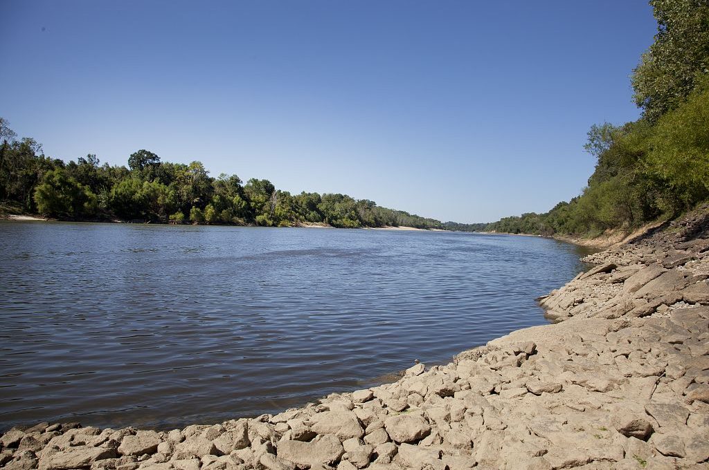
Down the Alabama River – Day four on August 14, 1814
SCROLL DOWN TO READ STORY
This amazing journal helps us visualize this historic journey down the Alabama River in 1814 Day four on August 14, 1814
(Continued)
Over the next few days, we will follow the day by day journey of the first survey of the Alabama River which started on August 11, 1814. With this journal, we will be able to visualize the sites and experience how long this historic journey took back in 1814.
(Transcription from Transactions of the Alabama Historical Society, Volume 2, 1898)
14th
Proceeded at 5 o’clock A. M. No. 30 W. 20 ch
N° 40 Wt. 1 Mile passed to the right of an Island
N°. 45 W*. 1 M. 40 ch—passed to the left of large Island
N°. 15 Wt 1 Mile—passed to the left of an Island bluff to the left opposite the Island, lands good on both sides to this place— say 40 ch above the end of the distance—Bank rocky at the bluff.
North 40 ch Improvements on both sides Durants1 old place called by the natives Pilth, to, hau, loth, cau. It is a large Improvt. and continues the full length of next course— lands here are rich on both sides—Durants place is on the right
N°. 40 Et. 40 ch—Field contd., as stated.
N°. 60 Et. 40 ch
N°. 75 Et 1 Mile—passed to the left of an Island2—Improvt. on the right—shoal water at the lower end of this distance
N°. 40 Et. 20 ch. Bluff on the right & spring—Bottom land on the left.
N°. 45 Wt. 20 ch. to the head of an Island3
N°. 80 Wt. 1 mile 40 ch—pass to the right of an Island—bluff contd. on the right & ends opposite the Island—good lands on the left to the lower end of the Island, then good on both sides— shoally a great part of this distance
N°. 55 Wt. 40 ch to a high red bluff on the right—lands good on both sides, a good looking creek4 from the right 10 ch above the end of this distance.
S°. 80 Wt. 20 ch—Bluff contd. on the right.
S°. 25 W. 1 mile passed to the left of a large Island5—Improvement on the left opposite passed 2 other Islands—An Improvt. on the left at the end of the distance—Cypress pond on the right.
S°. 60 Et. 1 Mile Rich lands on both sides
S°. 25 Wt. 30 ch. A handsome bluff on the left on which Is MTM. Durants old place6—Bottom on the right and low.
S°. 35 Wt 30 ch bluff continues on the left and open lands— bottom on the right.
S°. 75 Wt. 1 mile. Bluff & open woods continues on the left. Bottom on the right
S°. 70 Wt. 20 ch to the upper end of a bluff on the right—bottom lands on the left
S°. 30 Wt. 20 ch Along the bluff on the right—Bottom continues on the left—a good spring in the bluff at half distance.
South 20 ch along the bluff—Bottom continues on the left
S°. 30 Wt. 1 m. 40 ch. A fine spring on the right in the bank of the bluff—rich bottom on the left—bluff ends at 20 ch.
South 30 ch, to Bluff on the left—bottom on both sides to the bluff.
S°. 30 Wt. 20 ch Along the bluff—bottom on the right,—open, thin, pine land on the bluff.
S°. 60 Wt. 30 ch. Bluff contd. on the left & bottom on the right —Bluff ends & good lands on both sides
S°. 45 Wt. 3 Miles—passed to the right of an Island—Rich lands on both sides the whole distance—A creek7 from the left at 2 M. 60 ch—A field of corn to the right opposite the creek
S°. 65 Wt. 2 miles—Appearance of rich lands on both sides— 3 springs on the right at different distances—Pine lands on the left for the last 40 ch.
West 20 ch—High pine lands on the left and rich on the right
N°. 70 Wt. 30 ch—Pine hill contd. on the left—rich bottom on the right
N°. 45 Wt. 1 mile—Pine lands contd. on the left 20 ch. Spring branch on the right at 40 ch—good lands on both sides, bottom ceases on the right at 60 ch and a handsome bluff commences of open land & rocky banks.
N°. 85 Wt. 1 mile—Bluff contd. on the right [?]– rich lands opposite, on the left—Bluff on the right ends at 20 ch and good land commences—small spring at the end of the bluff—High, rich lands commence on the left at half distance.
N°. 75 Wt. 1 m. 20 ch—passed to the left of an Island at 60 ch —good high lands on the left—rich bottom on the right— a branch from the left—Improvt. on the right, below the Island
N°. 50 Wt. 1 mile—A high, open, Prairie bluff on the left— Improvt. contd. on the right & very rich bottom—passed to the left of an Island at from 20 to 40 ch—rich lands on the left from the upper end of the Island—Spring on the right, opposite the lower end of the Island.
N°. 30 Wt. 60 ch—The river shoally—Improvement on the right—Pine bluff on the left containing several springs & rocky banks—good lands opposite, and also below a sand beach on the left— rich lands on the right & a spring—A handsome bold runing branch, opposite the lower end of the beach, at an Improvt. on the right—High lands to the right at the end of this distance, intermixed with pine.
N°. 65 Wt. 30 ch to a bluff on the right8—rich lands on the left—thin on the right.
S°. 65 Wt. 40 ch along a piney bluff on the right—rich lands on the left
S°. 55 Wt. 2 M 40 ch—passed to the left of an Island,—Improvet & corn field on the right, at the mouth of a creek,9 A creek on the left—good lands on both sides
S°. 70 Wt. 2 miles— good lands continue on the right—thin, high lands & rocky banks on the left—good on the left at 1 mile —passed to the right of a small Island
S°. 65 Wt. 40 ch. good lands on both sides
S°. 30° Wt. 40 ch—High good lands & rocky shore to the right —rich bottom on the left
South—20 ch to a bluff of pine lands & rocky shore on the right—Rich on the left—a bad shoal—the best channel to the right—bluff ends at 20 ch.
S°. 40 Et. 1 mile—passed to the left of an Island—rocky banks to the left & good high lands—Bottom on the right.
S°. 60 Et. 30 ch. good lands on both sides
S°. 70 Et. 30 ch—A handsome bluff of tolerable good land, and a smooth rock bank on the right—rich bottom on the left. The bluff on the right continues the whole of this distance
N°. 50 Et. 30 ch—Bluff continues on the right—Bottom, and corn field on the left.
North 1 mile—Bluff contd. on the right—a small creek & good lands on the left
N°. 45 Et. 10 ch. to a rocky bluff on the left
East 10 ch. along the rocky bluff10—bottom on the right
S°. 30 Et. 1 mile—Bluff contd. on the left & bottom on the right—Bluff ends at half distance and good lands commence.
S°. 45 E*. 3 miles—good lands on both sides—passed to the left of an Island at 40 ch—corn field on the right—a bad shoal at half distance
S°. 30 Et. 1 mile—good lands on both sides—Improvt. on the right as 20 ch and contd. the whole distance—small creek on the left near the end.
South 10 ch along a rocky bluff11 on the left—Improvt. contd. on the right
S°. 40 Wt. 10 ch. Bluff contd. on the left—rich land and Improvt. contd. on the right
S°. 70 Wt. 10 ch Rocky bluff cont. on the left—good lands & Improvt contd on the right—thin lands on the bluff.
West—20 ch. Appears the same as on last course Improvt. continues—
N° 65 Wt. 3 miles—Lands thin on the left 1 mile thin good on both sides—best on the right—Improvt. on the right—ends on this course at 20 ch.
S°. 80 Wt. 1 m & 40 ch passed, immediately, to the left of an Island—a fine spring on the left opposite the Head of the Island—rocky banks on the left—rich lands on both sides.
S°. 60 Wt. 1 mile—good lands on both sides—a bluff rises on the right at 40 ch & lands thinner on that side.
S°. 40 Wt. 1 m. 40 ch—Bluff ends & good lands on both sides continues—highest on the right—The Cau, hau, ba river enters from the right at the termination of this distance12—The lands excellent above.
S°. 5 W. 60 ch—good lands on the right for 20 ch to a bluff which continues the whole of this distance—Rich bottom on the left.
So, 10 Et. 1 m. 40 ch Tolerable good, high, bluff lands on the right—Rich bottom on the left—A rocky bluff of good lands commences on the right near the end of this distance, and a rich piece of land above.
S°. 45 Et. 1 mile, Bluff of Rock with good lands on its summit for 20 ch where the rock ends at a sand beach on the right, or same side—Rich lands (bottom) on the left to near the end of this distance, where high lands & bluff commences—Bottom on the right, below the sand beach—Spring in the bluff near the end—another at the end—a branch from the left.
Encamped on the left shore at 51 M. 60 ch
1“Benjamin Durant, of Huguenot ancestry of South Carolina, married Sophia, sister of the famous Alexander, and daughter of Lachlan McGillivray, whose wife was the Indian maiden Schoy Marchand.
2Gaston.
3Old Hell.
4“Mulberry Creek.
5“Gardner’s Island.
6“The river, having made a great bend, again touches the Durant Place. See Note 27.
7Soapstone Creek, also called Tarver’s Mill Creek.
8This and the two succeeding paragraphs must refer to Selma and contiguous country, first called “High Soap Stone Bluff,” but on the location of a town here, called Selma at the suggestion of Hon. William R. King. The few white men who were in this part of the country as early as 1809 and 1810 knew this place as ‘High Soap Stone Bluff,’ but later in 1815, a white man by the name of Thomas Moore, having made his way through the wilderness from Tennessee, located at this point, the place taking the name of ‘Moore’s Bluff.’ from the few persons of that day who traded on the Alabama River in pole boats, yawls and dug-outs, which name the place retained until December 4th, 1820.”—Hardy’s History of Selma (1879), P- 7
9. “Valley Creek.
10“King’s Bluff, and King’s Bend, called in honor of Hon. Wm. R. King.
11Hatcher’s Bluff
12The Cahaba region is later described at some length and declared to be an Arcadia.
ALABAMA FOOTPRINTS – Volume I – IV: Four Volumes in One (Volume 1-4)
SAVE – BUY ONE GET ONE FREE! The first four Alabama Footprints books (listed below) have been combined into one book, Alabama Footprints – Volume I-IV –
ALABAMA FOOTPRINTS Exploration
ALABAMA FOOTPRINTS Settlement
ALABAMA FOOTPRINTS Pioneers
ALABAMA FOOTPRINTS Confrontation
From the time of the discovery of America restless, resolute, brave, and adventurous men and women crossed oceans and the wilderness in pursuit of their destiny. Many traveled to what would become the State of Alabama. They followed the Native American trails and their entrance into this area eventually pushed out the Native Americans. Over the years, many of their stories have been lost and/or forgotten. This book (four-books-in-one) reveals the stories published in volumes I-IV of the Alabama Footprints series.