The Mountain Stops Here
by
Shannon Hollon
Many folks in the hamlet of McCalla Alabama don’t know that the Appalachian mountains ends in their backyard. The oldest mountains in the United States of America(480 million years) starts in Newfoundland and 1600 miles later ends in McCalla. Before erosion they were higher than the Alps or Rockies.
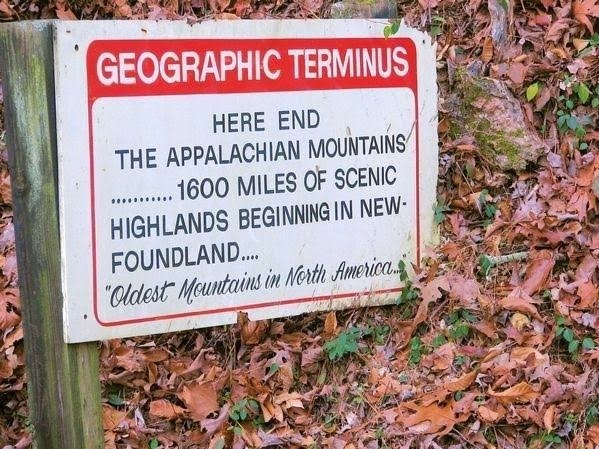 Geographic Terminus (Tannehill Historical State Park)
This range that stretches from Birmingham to McCalla had another oddity it is one of the few places in the world where all the main ingredients(iron ore,coal, limestone) for iron and steel making can be found in some places less than 3 miles from each other.
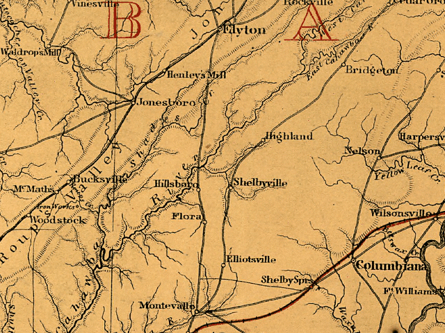 Map from 1865 of Roupes Valley
The highland range called Red Mountain (due to iron ore content) Rock Mountain and Shades Mountain are sandwiched in between the Cahaba and Warrior Coal fields which created Jones and Roupes Valley that was settled in 1816 and soon became the birthplace of the iron and steel industry of the South.


Love Tannehill.
Yup lived on the northern part of them tail end of Catskills Mts Appalachian Mts now the tail end here in Alabama. Love my Mountains
I think some in Wetumpka and even Tallassee, Alabama have made the same claim.
I’ve heard that in Fl panhandle lay claim that the App Mts end down there
Miranda
Chewacla state park claims it’s the last foothill in the mountain train.
Ends st Jaismine Hill Wetumpka
I got to see a small portion from the top of Mount Washington, a most beautiful place.
Used to be a similar sign in Tannehill State Park.
Obviously, a lot of places are trying to grab a piece of this pie but I was under the impression that Flagg Mountain in Weogufka, Alabama was the terminus for the Appalachian Mountains. There have been some discussions of extending the Appalachian Mountain Trail to Flagg Mountain and it does unofficially connect with the Pinhoti Trail on Cheaha Mountain which ultimately connects with the Appalachian Trail. Perhaps, we need an expert opinion and I am not an expert! 🙂
Ron I am sure you know this. Just curious how much of the trail have you explored?
I’m from Alabama and didn’t know this.
Gee, I thought it began in Maine.
Barry where do find these stories.
If you visit the Tannehill state park there is a sign going into the park that talks about the Appalachian Trail
The sign at the park talks about the mountain range, not the trail.
There is s CCC built Firetower similar to others built along the Appalachian Mountains during the Great Depression at the Alabama terminus. The plaque there describes the tower as such.
The southernmost mount over 1000ft in elevation in the Appalachian chain is Flagg Mountain, in Coosa County l, near Weogufka. It is the southern terminus of the Pinhoti trail
Coosa County!
I shared your post in Appalachian Americans.
This sign is inside Tannehill Historic Park.
https://g.co/kgs/zY6mc0
Yup, knew that. Helped construct & maintain sections of the Pinhoti Trail in 1974…
Hannah Nöel Jackson
Going north the trail ends in Maine. On the top of Mt Katahdin. Not in Newfoundland, Canada.
The sign and the article do not say where the Appalchian Trail starts or ends. This is about the Appalachian Mountains which do not end in Maine.
Cap Gaspe in Quebec Canada is the end of the North American portion. Called International Appalachian Trail when enter Canada. We have been there to the plaque about it – beautiful! At a lighthouse overlooking sea.
Fastest hiking of trail was done by a woman graduate of Samford University, Birmingham, AL.
Not anymore. A guy broke her record this year. Met her here in Dahlonega at Trail Fest two years ago.
Tom Lamb Wow! What they do is amazing, but not quite the same as hiking.
Actually they end at the last set of shoals in Centreville. You can view the change from the Appalachian mountains to the gulf coastal plain from the bridges by the the high school.
I just wonder how one part of the earth can be older than another when the entire earth was created at the same time, and how does this person know about the erosion. Land that has forests growing on the land soil does not erode when it is covered with vegetation. I greew up in that area back in the late 1940’s through the mid 1960’s so I know that area. McCalla is just Southwest of Bessemer Al.
You need to go back to school and pay attention this time as to how mountains are formed.
Tracey Bagwell you are the one that needs to study a book that really tells you how the mountains were formed. It is called the BIBLE. It plainly states that God created the heavens and the earth.What I would realy like for you to9 explain top me is who was around back then to measure the height of the mountains and what instruments did they use to measure them
Well sir after thousands of years of different plates smashing together the plates had to go somewhere so they went up, thus therefore forming mountains.im sorry sir that you’ll weren’t as educated in the 40 thru the mid 60s, but never stop educating yourself and you’ll have a lot less questions.try shutting your mouth and opening your ears.
As for the erosion after you get so high there are no trees.and if there’s rain there’s erosion vegetation or not
Sign is on the road going into Tannihill State park.
Right at Tannehill!
The rock formations and flora continue all the way down the Black Warrior River to Tuscaloosa…
When I was a student at the University of Alabama, my geology professor said the southern end of the Appalachian Plateau was along Rice Mine Road.
The North American portion ends in Maine but the Appalachian chain continues in Scotland… the two continents separated after the formation of the chain of mountains.
Love them mountains from south eastern kentucky
I never knew that. Very interesting.
I’ve been to McCalla a lot of times, mostly hills , not much in the way of a mountain! lol
Pretty sure the hill in my backyard in Mobile, AL is the terminus of the Appalachians. Just sayin’. Enjoyed the article though.
The article on Appalachian mountains was really informative. I have studied about it in my geography class. Nice information!
Went to Newfoundland this past summer. The mountains were incredible
Most beautiful place that I have ever seen.
Hmmm I was always told and read that Flagg mountain in Coosa county was the southern most point of the Appalachia’s
https://appalachiantrail.org/home/explore-the-trail
Mccalla? Not listed.
Richard Haynes, that is the trail. The mountains themselves run down well into central Alabama, gradually making way to the flat agricultural area heading south towards the Gulf. There has been talk of lengthening the AT into Alabama but not sure where it stands now.
I believe I’ve seen this sign at Tannehill State Park which is in McCalla.
Yeah but, do they have a sign?
Earl Brown Dale Watkins
Melanie Stickler Falconer
Andrea McCarthy
Jennifer Stickler Riddle
Springer Mountain is the Southern terminus of the AT trail but not the end of the Appalachians. Flagg Mountain in Coosa County is the southernmost 1,000 plus foot peak in the Appalachian chain, but lesser peaks extend even turther south. The only thing McCalla has is a sign with a dubious claim.
I missed it, and walked all the way to Vicksburg!
On the entrance road at Tannehill Ironworks Historical State Park
I have always thought the last foothill is in Tuscaloosa where Woods and Water is.
Susan McCorquodale it is
There a sign on top of lookout Mt it says the gateway to the Appalachian Mts fort Payne Alabama
I have all way heard red mountain in Birmingham was the most southern point of the Appalachian mts
I saw a sign on way to a job that said this is the end of it.
McCalla is not the end of the trail. It claims to be the southern most part of the Appalachian mountains.
Charlene Sharp I wondered if Rick was aware of this.
Are they talking about the Older Appalachians?
Flagg mountain in Coosa county is supposed to be the end I was told
Wonder why the Appalachian Trail doesn’t end in Bama sense the mountains end in Bama.
The Pinhoti Trail starts in Alabama and ties into the Appalachian Trail in Georgia, but agree it should also be part of the bigger trail.
At Tannehill Ironworks Historical State Park.
McCalla is making a bold and erroneous claim. Flagg Mountain in Coosa County is the southernmost Appalachian peak over 1,000 feet. The true end of the Appalachian chain extends even further south but its true end is subject to debate.
Cale Glenn
Why does the mountains end in AL but the trail only ends on GA
Getting closer.
Pinhoti Trail Alliance
Too old, where’s the newest mountains in North America?
Lol very confusing
There’s actually the opposite end in tannehill Alabama tannehill State Park.
I was not aware that it ended in McCalla.
McCalla? Really? I thought it would be closer to the eastern border to Georgia . . . somewhere around Cheaha Mountain.
Brenda W. Hand I had to look this one up. Yep, the research states McCalla, Jefferson Co., Alabama is the geographical end.
I always thought Cheaha, highest peak in Alabama!!
It is. But apparently it’s not the “last bump” of the Appalachians.
Barbara Gibbs I am not arguing with its authenticity; I’m just surprised as there are consistent mountains throughout the counties descending on the northeastern side of the state.
It’s funny to me that there is a brass star on the steps of a dorm at the University of Montevallo declaring it is the geographical center of the state.
Brenda W. Hand Where I come from (Kentucky) these are known as foothills. As for the brass star in Montebello, it has nothing to do with the geographical end of Appalachian foothills. That is a different geographical point.
Brenda W. Hand I went to Montevallo and the inscription says “near” the geographic center. What do they know, we really were!
Actually it ends in Elmore County just south of Wetumpka.
. . . at Ft. Toulouse?
Warren Jordan ,Yes and if I recall things correctly ,Elmore Co. was the Southernmost County to receive funding under LBJ’s Appalachian Development Act of 1965 as parting the War on Poverty .
Brenda W. Hand In the area of Blue Ridge and Willow Springs south of Ft Toulouse.
Geologically speaking, most of you are wrong.
aMelanie Stickler Falconer
Andrea McCarthy
I beg to differ…
Very interesting!
Bad link
You might want to check that link.
Kristie Law Wilson
Something has been wrong with your links for a couple of weeks now. They don’t take you to the actual story they show.
Worked for me
Bad link
Took me to some sort of questions or advertising
This sign is at Tannehill State Park, near McCalla , Alabama…
Bad link also.
Yep, I have posted this before. But rather than the terminus, it is actually the beginning of the Appalachian mountain range.
Too many shady things pop up on this blog!!
This has happened to me the last few times I clicked on it. I have tried to let her know through posts. I will not visit her page until something is done about the bad link.
Connie H Bunker I don’t even try to open that anymore. Pop-ups as soon as I click it.
This is on the entrance to Tannehill