Down the Alabama River in 1814 Day Seven on August 17, 1814
This amazing journal helps us visualize this historic journey down the Alabama River on August 17, 1814 Day seven (Continued)
Scroll down to read story
Over the next few days, we will follow the day by day journey of the first survey of the Alabama River which started on August 11, 1814. With this journal, we will be able to visualize the sites and experience how long this historic journey took back in 1814.
(Transcription from Transactions of the Alabama Historical Society, Volume 2, 1898)
August 17, 1814
Proceeded at 5 o’clock A. M.
S°. 10 Et. 40 ch—lands good on both sides.
S°. 30 Et. 40 ch—good lands on left & high pine lands on the right.
S°. 75 Et. 20 ch—High on the right & bottom on the left
East—1 m 20 ch—High on the right for a small distance thence descends gradually to rich bottom—good Bottom land on the left.
S°. 70 Et. 2 Miles—Lands good on both sides
S°. 50 Et. 1 mile to the uper end of a high, handsome Red Bluff on the right—lands good on both sides—passed to the right of an Island1 at 20 to 40 ch—a part timbered & rich— lands high on the right opposite the timbered part of the Island and a good spring 20 ch above the bluff.
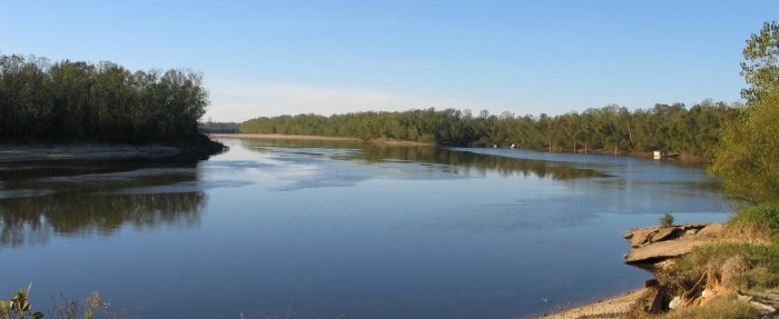
Alabama River
S°. 85 Et. 4 miles, along the above named bluff of thin level land covered with pine and banks 80 feet high—rich bottom on the left—lands on the right good, & bluff ends, at 20 ch & from thence to the end of this course A fine spring on the right at 30 ch—The land on the left is excellent.
S°. 65 Et. 40 ch—The land rizes on the left to a bluff with rocky banks & pine growth—On the right a rich bottom A large creek from the left at 20 ch—bluff increases below the creek, in height.
S°. 35 Et. 30 ch.—A high, broken bluff on the left—red corn [ ?] land on the top mixed with pine—bottom on the right— a fine bold creek from the left near the commencement of this course
South 40 ch—High pine lands contd. on the left & rich bottom on the right 2
S°. 20 Wt. 2 Miles—Bottom contd. en the right—lands lower to the left & descend to a bottom at about 1 mile—lands rise on the right at 1 m 40 ch and continues high & rich to the end of this distance
No. 10 Wt. 2 M 10 ch—passed ‘o the left of an Island at 1 M 40 ch—4 springs to the right, near the beginning—Pine lands on both sides of rich bottom—Spring branch from the left 30 ch above the Island.
S°. 30 Wt. 20 ch—a rocky bluff on the left & good bottom on the right.
S°. 45 Wt. 1 m 20 ch—Bluff contd. on the left & bottom on the right—good lands on the bluff—2 springs to the left at 40 ch and a branch to the right nearly opposite.
S°. 60 W. 1 Mile—Rich, high lands on the left & bottom on the right—rocky banks on the left and a branch at 60 ch.
S°. 75 Wt. 1 mile to the uper end of a large timbered Island— bottom lands on both sides—a branch to the right at 60 ch.
S°. 85 Wt. 1 m 20 ch—passed to the right of the above named Island—This Island has but little water on the left—the main channel on the right, about 50 yds wide—a bluff on the left opposite the Island—the whole good lands on both sides—The timbered lands on this Island is very good & lies high—a very old, small Improvt. is on the Island.
This Island3 has become notorious from the circumstance of Col. Benton’s discovering 3 or 400 Indians on it in descending the river in May or June last, belonging to the war party that had declined, or refused, to surrender, and suffering them to escape punishment by pretending to be then on their way to Fort Claiborne for the purpose of surrendering—It is supposed to be a part of the same who were afterwards at Pensacola with Francis & McQueen.
S°. 55 Wt. 1 mile—lands, fine bottom on the right—Island contd. on the left—lands to the south of the Island, rich bottom —Island ends at 40 ch—A small creek & bluff on the right 10 ch. above the end—the bluff continues to the end of the course —Pine on its top & a fine spring at the end of the distance
S°. 10 W. 2 miles—High, Piney lands on the right—Very rich bottom on the left—High lands recede gradually from the river on the right and bottom commences at 20 ch—a branch from the left at 60 ch.
S°. 45 W. 20 ch—High lands to the left, mixed with Pine— Bottom on the right.
No. 70 Wt. 2 m 40 ch.—High, rich lands on the left—Prime bottom on the right—Spring branch on the left at 20 ch another at 1 m 20 ch—a branch on the right at 60 ch—another Spring on the left at 1 m 40—An Improvt. on the right at 1 m. 60 ch— Another at 2 miles—Spring branch on the right a small distance below the Improvt.—a third Improvt. near the end of the distance
S°. 45 W. 20 ch—lands good on both sides
S°. 10 W. 1 m. 60 ch—Excellent lands on both sides, to a handsome bluff on the right—a creek to the right4
S°. 45 Et. 2 m 20 ch—Bluff contd. on the right 20 ch—passed to the left of an Island at from 40 ch to 1 m 10 ch—bottom to the left, also on the right below the bluff—Spring to the left near the end of this distance.
No. 15 Et. 20 ch good lands (prime) on both sides
S°. 10 E . 2 M 40 ch—Prime lands on both sides—very old Improvt. on the right at 1 mile—Creek from the left at the same distance.—The lands on the right lie high, very rich & scarce of timber; supposed to be the effect of very old Improvts. that appear extensive.
No. 20 Et. 1 m 20 ch lands good on the right near the river— high & piney off from thence a short distance—Excellent land on the left—a branch from the right at 1 mile—a small branch from the right at the end.
S°. 35 Et. 20 ch—good lands on both sides—a bottom on the left and spring branch from the right.
S°. 60 Et. 3 miles—2 springs on the right at 60 ch high lands on the right near the river—bottom on the left with rich high lands near the lower end high lands cease at 1 mile & bottom succeeds—passed the mouth of a large creek called Little Limestone5 or uper limestone, and is the largest of the two of that name. It is from the left.
No. 20 Et. 20 ch—lands good on both sides—rocky banks on the left
South 1 mile—Lands continued good on both sides— passed the mouth of lower Limestone Creek6 at 20 ch above the end of this distance—Enters from the left.
No. 10 Wt. 40 ch. Lands high & piney to the left—rich bottom on the right & a spring on each side on this course
So. 35 Wt. 20 ch. A high poor bluff on the left & rich bottom to the right a spring on the left.
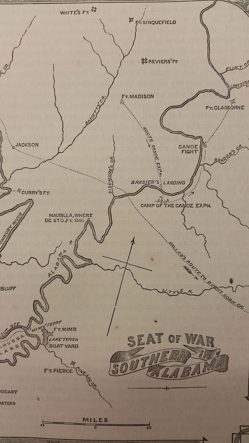
S°. 60 Wt 20 ch To Fort Claibourne7 situated on a high pine bluff of 150 feet perpendicular, on the left side the river— A rich bottom to the right and a spring under the Fort in the river bank to the left.
Map shows Fort Claiborne – upper right (Alabama Department of Archives and History)
West 30 ch—Bluff continues, lower but still poor & piney— rich bottom on the right.
No. 55 W. 60 ch—Bluff decreasing & piney—rich bottom on the right & largely Improved.—landed on the left at John Weatherfords ferry, at the end of the bluff at 45 minutes after 3 O’Clock P. M. & encamped at 41 m. 20 ch.
Note—The road8 of communication between Fort St. Stephens & Milledgeville in Georgia crosses the Alabama at this ferry, the property of a friendly Creek Indian, brother to the noted chief who was a principal leader in the distruction of Fort Mimms.
The bluff on which the Fort is situated is called the Alabama heights. It overlooks an extensive, valuable bottom on the right bank, which is said to be backed with a bluff of high Pine lands from the foot of which run many fine springs that will prove of great utility in the future settlement of this part of the country— above this place lies large & extensive bodies of prime bottom, and, as is said, high lands—the situation & water good & healthy of course will become a valuable acquisition to the United States. It is by lands from 20 to 30 miles above Fort Mimms & 50 miles above Fort Stoddard and 90 to 100 Miles above Mobile.
Fort Claibourne is a strong built Stockade Fort nearly a square on the centre of three squares are built Blockhouses which have the effect of Salient Angles, the outer ends of which are shaped so as to have the effect of the face of Bastions in defence—there is also one of them in the line of an irregular off set in the work, made to avoid including part of a ravine.
‘
1“Steans Island.
2 In the vicinity of Bell’s Landing.
3“Hane’s Island.
4 “Silver Creek.
5Now called Flat Creek.
6Now called Limestone.
7Now Claiborne. The remains of the fort are still visible. It was built by General F. L. Claiborne in November, 1813. as a base of supplies on his invasion of the Creek country from the southwest. The best description of the fort is that here given by Tatum. The white bluff and long steps of Claiborne are prominent objects on the Alabama River.
Nothing can be found in the existing War Department records as to the founding, occupancy or abandonment of Fort Claiborne. Gardner’s Dictionary of the Army of the U. S., p. 578, says that it was named after Brig. Gen. Claiborne, as is generally stated. That publication also gives Fort Montgomery, opposite the Cut Off, at three miles distance, as named for Bvt. Maj. E. Montgomery, 7th Infantry. There is no plan of either on record, but the location of Fort Claiborne, as well as of other posts, is given on the early printed Map of Alabama, constructed from surveys of the General Land Office, &c., by John Mellish, 18181810.
After the Creek treaty of Aug. o. 1814, Gov. David Holmes, of the Mississippi Territory, by proclamation dated June 29, 1815. created Monroe County to embrace all the ceded lands. On Dec. 9, 1815. the Territorial Assembly designated Fort Claiborne as the place for holding the Courts of the County. It remained the seat of Justice until 1832. In its early days it was “a place of fame,” and many of the leading public men had residences there. It was very unhealthy, however, and this was one cause of its downfall. Railroad competition destroyed its commercial importance. See Pickett’s Alabama, vol. ii, p. 320; Brewer’s Alabama, pp. 434-5; and Ball’s Clarke County, p. 458.
8The route crossing here from St. Stephens merged to the east in the Federal Road. It is noteworthy that Sam Dale in carrying the news of the victory at New Orleans did not cross at Mims Ferry and pursue the Federal Road but took a more northerly route and crossed the Alabama at Randon’s, mentioned by Tatum lower down. This may have been due to high water at Nannahubba Island. See Claiborne’s Dale, p. 160. The brother referred to is John Weatherford, of the preceeding paragraph.
ALABAMA FOOTPRINTS – Volume I – IV: Four Volumes in One (Volume 1-4)
SAVE – BUY ONE GET ONE FREE! The first four Alabama Footprints books (listed below) have been combined into one book, Alabama Footprints – Volume I-IV –
- ALABAMA FOOTPRINTS Exploration
- ALABAMA FOOTPRINTS Settlement
- ALABAMA FOOTPRINTS Pioneers
- ALABAMA FOOTPRINTS Confrontation
From the time of the discovery of America restless, resolute, brave, and adventurous men and women crossed oceans and the wilderness in pursuit of their destiny. Many traveled to what would become the State of Alabama. They followed the Native American trails and their entrance into this area eventually pushed out the Native Americans. Over the years, many of their stories have been lost and/or forgotten. This book (four-books-in-one) reveals the stories published in volumes I-IV of the Alabama Footprints series.