Amazing journal helps us visualize this historic journey to survey the Alabama River in 1814 Day one
Over the next few days, we will follow the day by day journey of the first survey of the Alabama River which started on August 11, 1814. With this journal, we will be able to visualize the sites and experience how long this historic journey took back in 1814.
(Transcription from Transactions of the Alabama Historical Society, Volume 2, 1898)
TOPOGRAPHICAL NOTES AND OBSERVATIONS ON THE ALABAMA RIVER, AUGUST, 1814.1 BY MAJOR HOWELL TATUM.2
Edited By Peter J. Hamilton And Thomas M. Owen.
Introduction. By Mr. Hamilton.
This valuable manuscript of the first survey of the Alabama River is to be the property of the Mobile Historical Society, the gift of Mr. Louis Stein. It was found among the papers of his father, Albert Stein, the eminent engineer of New Orleans and Mobile, and builder of the Mobile City Water Works. It seems originally to have come from the papers of Mr. A. Cantrell, and was presented to Mr. Stein as having reference to Mobile. It is a book of 5″x7″ inches, opening at the top, and is evidently field notes made on the boat as Tatum descended the river. The first use made of the document was in Colonial Mobile in, pp. 374-376. A copy of the Journal is on file in the office of the Chief of Engineers, U. S. Army, but no map accompanies it.
The paper opens with Tatum’s call by Andrew Jackson from Nashville to Fort Jackson. There he witnessed the treaty, or more properly capitulation, of the Creeks on August 9, 1814, which ended the great Creek War instigated by Tecumseh during the War of 1812 between the United States and Great Britain.
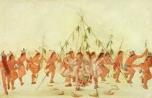
This, the greatest of all struggles between the white man and the Indian, began with the battle of Burnt Corn July 27, 1813, and its most striking early features were the massacre of Fort Mims near the Tensaw River on August 30, the Canoe Fight on the Alabama River below Fort Claiborne on November 12, and General Claiborne’s victory at the Holy Ground on December 23. The Indians had intended to exterminate the settlements on the Bigbee and Tensaw, and so the war at first was largely defensive on the part of the whites. A painstaking study of this side of it will be found in Halbert and Ball’s Creek War. Mobile had been captured by the American General Wilkinson on April 13, 1813, but the Indians spared it because their friends the Spaniards expected to recapture it.3 The war assumed quite another character, however, when Jackson invaded the Creek territory from Tennessee by way of the Coosa Valley. When the struggle began, the Creeks were the undisputed owners of that part of Mississippi Territory embracing the Alabama River basin from the mountains to the Mobile, and of Georgia west of the Ocmulgee River. When it ended with the treaty referred to in the text, all west of the Coosa and a line drawn southeastwardly from Fort Jackson near Wetumpka, embracing the great agricultural centre of Alabama, was ceded to the United States and open to white settlement. Before then the settlers had been traders, who intermarried with the Indians, and only afterwards could there come pioneer white families of settlers. Tatum’s Journal shows the river just at this turning point. He passes future city sites without knowing it, and dwells on Indian remains and battles.
The text of this treaty, which made Alabama possible by adding the eastern river basin to that of the well settled Tombigbee, may be found in 7 United States Statutes at large, p. 120, et seq.
The Journal.
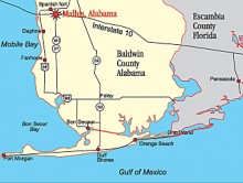
On the 27th of June 1814 the undersigned received a letter of appointment from Maj. Genl. Jackson, as Topographical Engineer of the 7th Military District, to which he was then attached as commanding General. This letter instructed me, in case of acceptance, to repair to his headquarters wherever they might be. On the 28th a letter of acceptance was written & forwarded, and on the sixth July I proceeded from Nashville, in Tennessee, and arrived at Head Quarters at Fort Jackson4, near the junction of the Coosa & Tallapoosa rivers on the morning of the 21 st and reported my arrival to the Commanding General, and entered upon the duties attached to the office aforesaid. The Troops stationed at this post at the time of my arrival consisted of five companies of the 3d Regt. U. S. Infantry, supposed 500 strong, non-commissioned officers included.
From the above date to the 11th August inclusive, the time of the General was principally taken up in arrangements for, and completing a capitulation with the Creek Nation, which was fully effected & signed on the day last mentioned, and forwarded to the department of War.

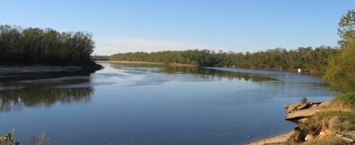
About this time Colonel P. Pippin5 arrived from Fort Williams,6with part of his regiment of West Tennessee Militia, accompanied by Capt. I. S. Baker’s7 company of the 44th U. S. Infantry. On the arrival of this reinforcement, the commanding general caused preparations to be made for descending the Coosa & Alabama to Mobile, with the regular forces then at that place, and on the 11th of the same month proceeded in boats then at that place, by which the 3d had heretofore ascended, leaving Col. Pippin in command of that Fort and Fort Decatur,8 to which post a company of said militia had been previously detached as a relief to the North Carolina militia then at that place. The descent of the river commenced at 1 o’clock p. m. The undersigned embarked on board of the same boat with the Command General & his staff, with instructions to take the courses & distances of the Alabama river in the descent, from the junction of the Coosa and Tallapoosa, as correctly as could be done under existing circumstances. The result is as follows, viz:
August 11th, 1814
Embarked at 1 O’clock P. M. & proceeded down the Coosa river to its junction with the Tallapoosa, Miles 40 ch. Thence S° 25° Wt 40 chains.
S° 45 W 40 chains rec’d a creek from the left at this distance and find the lands good on both sides
S° 10 Wt 40 ch. on the left is a rich bend,9 (formed partly by the Tallapoosa) which includes several small Indian plantations—The land is low, level & rich on both sides— The river shoally from the junction to this place—passed to the right of an Island.
N° 55 Wt 40 ch. Bluff & plantation on the left.
N° 30 Wt 1 M. to the upper end of a high bluff on the right— lands low and rich on both sides to this place— Improvements on the right.
West 30 chains. Bluff cont on the right—low & rich on the left— Spring on the right at ‘he end.
S° 25 Wt 20 ch. The Coosawda Town10 stood on a high bluff on the right, until burned by Col. Gibson11 of the Tennessee Volunteers in April last—lands low & rich on the left
S° 30 Et 1 M. rich fields & land on the right, below the Coosawda and level rich land on the left—a small creek from the left 60 ch. supposed to be Weatherfords Creek.
S° 10 Wt 2 M—Lands low on the left & higher on the right & good on both sides—passed to the left of a large Island.
S° 55 Wt 40 ch. lands low & rich on both sides
S° 45 Et 20 ch. Shoal water for this distance good lands
S° 80 Et 20 ch. contd on both sides
S° 35 Et 40 ch.—to a bluff on the right lands appear good on both sides to this place—at 20 ch. received a small creek from the left.
S° 25 Et 30 ch. lands low & rich on both sides
S° 20 Wt 30 ch. to the upper end of a Red Bluff lands good on both sides—Piney on the bluff (say on the left)
West 20 ch. Bluff continues on the left.
N° 25 Wt 30 ch. good lands on both sides—a clearing on the right.
N° 65 Wt 1 M. good lands on both sides—Encamped on the left at 10 ½| Ms. from the Junction and from the Fort—17M.
1To Mr. Hamilton is due the courtesy of securing a copy of this valuable journal for the Transactions, which he has kindly caused to be made at his personal expense. The editorial notes and comments will it is hoped add an interest altogether beyond the text. Every effort has been made to secure accuracy.
2Maj. Howell Tatum was born probably in North Carolina. Particulars of his early life are unknown. The following is a summary of his Revolutionary War service in that State: Ensign, Sept. 1, 1775; Second Lieutenant, Jan. 4, 1776; Lieutenant, March 28, 1776; Captain, April 3, 1777; captured at fall of Charleston May 12, 1780; exchanged June 14, 17S1. He was brevet Major.
At the meeting of the North Carolina Society of the Cincinnati, 1785, he was elected Secretary, and he is supposed to have held that position at the date of his removal to Tennessee about 1790.
He is known to have held the following public offices in Tennessee: Treasurer Western District (Middle Tennessee), 1794-96; Attorney General of same, 1796-97; Supreme Court Judge, May 12, 1797, to Sept. 20. 1798, and afterwards (1807 about) one of the commissioners to adjust land claims between North Carolina and Tennessee.
Gardner’s Dictionary, Army of the U. S. (1853), gives his record in the War of 1812: “Principal topog. cngr. (rk Major) of Ten. Volrs. under M. Gen. Jackson. 26 Sept., ’13 to May. ’14: and again in the defence of N. Orleans, and disting. in battle of 8 Jan.. ’15.”
Nothing is known of his family. He died in 1823. as appears from a statement in 3 Yerger’s Tcun. Reports, p. 85. An effort is being made to collect materials for a full biographical sketch.
3Monette’s Valley Miss., vol. ii., p. 411, note. See Bibliographical Note to the paper on the “Surrender of Weatherford,” infra.
4This is on a bluff of the Coosa River a short distance below Wetumpka, where the Tallapoosa is in sight to the east. It was famous before Jackson’s day, for he only repaired a fort built by the French in Bienville’s time and called Fort Toulouse. This was built in 1714 and proved of great use in checking the military and commercial advance of the English from the Carolinas and Georgia. In their turn the English built Fort Okfuskee on the Tallapoosa to match the French, but were not so successful in Indian policy as their rivals. When by the treaty of Paris the British acquired the continent to the Mississippi River, these posts became of little value and Fort Toulouse was permitted to fall into decay. A fuller study of its history will be found in Colonial Mobile, pp. 158-165.
The most interesting early event connected with it was the massacre of Captain Marchand. placed by Pickett in 1722, and the execution of his murderers. Marchand’s Indian daughter was, by the Scotch trader Lachlan McGillivray, the mother of the wily Alexander McGillivray (1746— Feb. 17, 1793), by some considered the most distinguished product of Alabama.
Another romantic incident of the history of the fort was that a commander is said to have lived there with a woman who claimed to be the escaped daughter-in-law of Peter the Great. The most famous later event was the surrender here to Jackson of McGillivray’s nephew, William Weatherford, the head and front of the Creek war. This was before Tatum’s arrival.
For some time after the close of hostilities a garrison was maintained there. It thus became a destination point for emigrants coming the Federal road from Georgia. The large influx of settlers in its vicinity and in the contiguous region caused the establishment of Montgomery County, Dec. 6, 1816, by the last Legislature of the Mississippi Territory. Ft. Jackson was designated as the temporary place of holding courts. In 1816 a Post Office had been established at the fort with Wm. R. Ross, of Va., as P. M. In June, 1817, was held the first Orphan’s Court, of the County, Henry D. Stone being Chief Justice. Here subsequent sessions were held until May 9. 1818. when the Court convened at the “Town of Alabama.” The site of the old fort has now been all but obliterated by the plough.
5This was Philip Pipkin, of Tenn., Col. 1st West Tenn. reg. 6 mos. mila Volrs. June 20, 1814.
6At the mouth of Cedar Creek in Talladega County about 60 miles above Ft. Jackson; built by Gen. Jackson before he marched to Horse Shoe bend and named for Col. John Williams, of the 39th Inf.
7Isaac L. Baker, of Ken., who did valuable service in the army, 18121817.
8On the Tallapoosa river; built by the troops under Col. Homer V. Milton, in March, 1814. Gov. John Sevier, of Tenn., while locating the Creek boundary, died and was buried there in 1815. Within the last decade his remains have been removed to his native State.
9Now called the “Big Bend.
10During the Creek War all hostile Indians were known as Creeks, but so far as this was used genetically it was incorrect. To the French this region above and below the river junction was “Aux Alibamons,” and from it the main stream received the name which has named the State of Alabama. They were allies of the Muscogees, but more likely Choctaw in blood. Coosada (Conshati) was one of the principal Alibamon settlements. Its inhabitants, at least in part, abandoned it after the peace of Paris, and Romans in 1772 notes them as having been on the lower Tombigbee and Mobile near the kindred Okchays. Hawkins says in 1798 that some had gone beyond the Mississippi; but he anticipated their return. Coo-sau-dee he describes as a compact little town opposite some conic mounds of earth. It is on the west bank of the river, three miles below the confluence of the Coosa and Tallapoosa. See Wyman’s paper on “Early Times,” etc., supra.
11John H. Gibson, of Tenn., Maj. of Tenn. Cavalry Vols. 1812-1814; Lt. Col. of Dyer’s Reg., Coffee’s Brigade Tenn. Mounted Gunmen Sept. 28, 1814; distinguished and wounded in first battle of New Orleans, Dec. 23, 1814.
(Continued tomorrow)
ALABAMA FOOTPRINTS – Volume I – IV: Four Volumes in One
The first four Alabama Footprints books – Volumes 1-IV have been combined into one book
- ALABAMA FOOTPRINTS Exploration
- ALABAMA FOOTPRINTS Settlement
- ALABAMA FOOTPRINTS Pioneers
- ALABAMA FOOTPRINTS Statehood


I tried to join, but apparently too complicated for me.