Down the Alabama River in 1814 Day Nine on August 19, 1814
(Continued) An amazing journal helps us visualize this historic journey down the Alabama River on August 19, 1814 Day Nine
Scroll down to read story
Over the next few days, we will follow the day by day journey of the first survey of the Alabama River which started on August 11, 1814. With this journal, we will be able to visualize the sites and experience how long this historic journey took back in 1814.
(Transcription from Transactions of the Alabama Historical Society, Volume 2, 1898)
Patron $2+ member story –
August 19, 1814
S°. 40 W. contd.—1 m 20 ch—Plantation on the right—continued, on a valuable rich tract of bottom land—Rich bottom also on the left—plantation ends at 30 ch.
S°. 75 W. 60 ch—Rich lands on both sides—Improvt. on the left at the commencement—A small Improvt. on the right opposite the lower end of the former
S°. 35 Wt 40 ch—Bottom on both sides with pine lands on the right at 20 ch from the river—Improvt. on the left at 20 ch belonging to Sizemore a white man married to a sister of D. Baileys1— The bottom on the right widens in descending the river, on the next course—another Improvt. on the left belonging to the same Sizemore—He has another, which is his principal one on the right.271
S°. 20 Wt. 1 m 40 ch Improvt. on the left contd.—Rich bottom on both sides—a small branch from the right.
S°. 40 W. 1 mile—An Improvt. on the right at the commit. — Rich on both sides
South 20 ch—Rich lands on both sides
S°. 10 Et. 2 m 20 ch—Rich lands on both sides—A valuable plantation on the right at 1 m & 40 ch belonging to a Mrs. Dyer a half breed Indian of the friendly party.
S°. 30 Wt. 40 ch. Rich lands & another Improvt. or plantation on the right—Valuable lands on both sides & a handsome low bluff on the left.
S°. 55 Wt. 1 m a plantation on the left at 20 to 30 ch—passed to the right of an Island opposite—lands rich on both sides a large creek from the left 10 ch below beginning, passed close to the left shore—a bad shoal at the upper end & in the right hand passage—Improvt. on the right
N°. 65 Wt. 60 ch—Rich bottom on both sides
N°. 25 Wt. 40 ch to a beautiful bluff of rich valuable land & Improvt. on the left—rich lands on both sides, bottom lowest on the right.
N°. 5 NW. 60 ch Rich bottom on both sides—Improvt. contd. on the left
N°. 45 Wt. 40 ch—A Valuable Improvt. on the right from 20 to 30 ch below—A sand beach on the left—keep close in, with the right shore.
S°. 65 Wt. 40 ch—To the Choctaw-Bluff3 on the right—This is a handsome bluff of flat pine land & contains a small Impros”. —Rich low bottom on the left—a branch on the right at 20 ch—Improvt. above the branch.
S°. 5 Wt. 1 mile—A large Improvt. on the left—a spring in the bluff—a small Improvt. on the left at 60 ch
S°. 55 Wt. 2 miles—An old Improvt. on the left at the beginning—another on the right at 20 ch—Improvements & good high bottom land commences at 1 m 40 ch, on a handsome low bluff affording a good situation for a settlement—an Improvt. on the left & old 60 ch above the end—A large creek4 from the right at 1 mile—Bottom on the left
South 1 m 20 ch—An old Improvt. on the left Improvt. on the right from 60 ch to the end of this distance
S°. 45 Et. 1 mile—Along a handsome bluff of rich land on the right—This bluff may be said to contain high bottom land. It contains an old Improvt. near the upper end which continues the same appearances to the end of the distance—bottom on the left.
East 1 m 40 ch—Improvt on the right at the commencement, on a handsome bluff contd.—another 40 ch below on the same side & bluff—low bottom on the left—passed the mouth of a small lake at 1 m 20 ch from the left.
South 20 ch—Bottom on both sides—passed the mouth of Little river5 from the left
S°. 70 Wt. 1 m—Improvts. of Samuel Manack6 a friendly half breed, on both sides at the commencement & good lands on both sides.
N°. 85 Wt. 60 ch—Rich bottom on both sides, an old Improvt. on the left at the lower end of this course
N°. 45 Wt. 1 m 20 ch—Rich bottom on both sides
N°. 35 Wt. 40 ch—Bottom low & rich on both sides
West 20 ch—a sharp low point on the left—High bottom on the right
S°. 25 Wt. 40 ch—low point contd. on the left—lands higher on the right making a low handsome bluff & open lands of good quality on the summit.
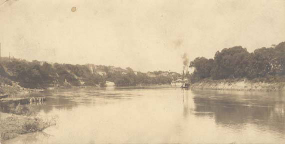
Steamboat on the Alabama River (Alabama Department of Archives and History)
S°. 45 Et. 2 M 60 ch—A handsome Improvt. on the right at 30 ch—lands higher on the left, but still low & swampy Improvt. on the right at 2 miles—A plantation on the left commencing at the end of this distance, and large. This is David Taits7 plantation, a pretended friendly half breed chief. Nephew to Alexr. MeGilvry & half brother to Wm. & John Weatherfords before named—John is a staunch friend—William commanded at the fall of Fort Mimms, with the war party and Tait suspected of pretending friendship to cover the large property of himself & William—He was never known to use any influence or activity in suppressing the outrages committed by his brother William & the nation. John, on the contrary, was always actively engaged with the whites in every instance—at the heights
South 40 ch Taits plantation on the left contd.—bottom on both sides. ‘-ij
S°. 50 Wt. 1 mile An Improvt. on the left at 20 ch—bottom on both sides
N°. 80 Wt. 1 m 60 ch—Excellent lands on both sides, open & cainey on the left—thick woods & low on the right
S°. 45 W. 40 ch—a handsome rich bluff of level bottom on the right—low, and supposed, swampy on the left—The margin on the right, open & cainey
N°. 10 Wt. 1 mile—Open rich lands on the right resembling old Improvts. & low bluff contd.—On the left low swamp lands—A creek from the left near the end of this course
N°. 85 Wt. 1 m 40 ch The lands rich, and lie well, on the left— Low & Swampy on the right—a lake Cr from the right at 1 m 20 ch.
South 30 ch.—Bluff & high bottom on the right—Swamp on the left
S°. 45 Et. 50 ch—Bluff on the right & swamp on the left continued—
S°. 15 Wt 40 ch—A bluff on the left having the appearance of an old improvement—Low lands on the right, at the point, then rises to a bluff of good lands at 20 ch
S°. 30 Et. 2 miles—Low & Swampy on the left—a low bluff & good lands on the right—Good lands on the left commence at 1 m 40 ch and low bottom commences on the right at the same distance—A large plantation on the left at the end of this course, and a small, old Improvt. on the right, opposite.
N°. 85 Wt. 20 ch—plantation contd. on the left & low bottom on the right
S°. 85 Wt. 20 ch—plantation contd. on the left & low bottom on the right—The river which has been from 250 to 300 yds wide from Fort Claibourne—here narrows to about 120 yds
N°. 45 Wt. 1 m 40 ch low bottom on the right—Higher & rich on the left –
West 40 ch—Bottom high on the right & low on the left.
S°. 45 Wt. 40 ch—Lands the same as in the last course
N°. 10 Wt. 40 ch—Lands low & flat on both sides
S°. 30 Et. 60 ch. An old Improvt. & high bottom on the right —low on the left.
S°. 60 Et. 1 mile—A plantation on the right belonging to Mrs. Dunn a half breed woman, commences at the beginning of this course and runs down nearly the whole distance—low bottom on both sides nearly the whole of this course & distance
South 40 ch—Bottom higher on the left lower on the right
S°. 50 Wt. 20 ch—Lands contd. as on last course. An old Improvt. on the left
N°. 80 Wt. 40 ch—Lands contd. the same on both sides, another old Improvt. on the left
N°. 35 Wt. 40 ch—Old Improvt. contd on the left—low bottom on the right—This old Improvt. has the appearance of a cain prairie
S°. 60 Wt. 40 ch—Lands low on both sides
S°. 10 Wt. 60 ch—Bottom highest on the right—swamp on the left.
N°. 15 Et. 30 ch—lands same as above
S°. 45 Wt. 70 ch—A bluff & bottom lands on the left—A large old field on the left—low on the right—This course ends at the Cut-Off. 46 m 20 ch below the junction8
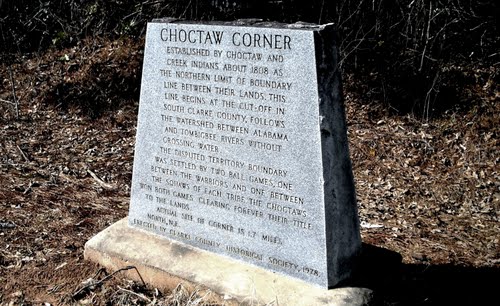
At this place the Indian boundary line9 on the west crosses the Alabama river from the southward or eastward & enters the cut-off and continues down the same to a point which formerly answered as a corner to the Choctaw & Creek Tribes & now answers the same purpose as between the United States & Creeks, from whence it runs northwardly, bending on the lines of lands ceeded by the Choctaws, to the United States.
The cut-off, is a fork which breaks through the western bank of the Alabama and runs from thence by various courses, into the Tombigby river at the landing of Carson’s ferry at the crossing of the road leading from Fort Stoddard to Georgia, commonly called the Federal Road10‘ —This road crosses the Alabama about 3 miles below where the cut-off breaks out at Mimm’s Ferry—Fort Mimms stood about 1 m. 20 ch, nearly East, from this ferry, on the road—and about 3 miles, nearly south from the cut-off.
It being between sunset & dark when the boats arrived at the cut-off, and the commanding general determining to descend by night—I became impracticable to continue the survey—It therefore ceased at this place, and the more readily, as the cutoff, Alabama & Mobile rivers, as well as the Tombigby below this, had been heretofore surveyed & proper representations (as was understood) forwarded to the department of War, by Majr. General Gaines while stationed at Fort Stoddard.
From the rapid manner of descending the Alabama, no other mode could be devised for the measurement of the different courses than conjecture—The distances are therefore most likely to be over rated, as objects on a narrow water appears to be more distant than they really are—I believe it is the case in this instance, as upon examination, I find the difference of Latitude to be 127 ch 40 Links, whereas from the best estimate I have been able to make (having no mode of taking observations for want of the necessary instruments) the difference ought to be about 100 miles—The line of departure when correctly ascertained upon true distances, actually measured, or the foregoing corrected by a land base actually & accurately measured, will probably be about S°. 45° West, instead of No. 37 as it now appears—The departure as represented on the map of this survey appears to be 96 M 23 ch 32 links—the base, or line of departure being in length 160 miles—This base will be much shortened whenever the true distances are ascertained—the line of departure will also be found to be further west—but the distance, it is believed, will be nearly the same, the long distances being those most subject to error, and those are mostly found on the southwardly & eastwardly courses. The only benefit therefore, to be derived from this map is that, It shows nearly the true course & various meanders of this celebrated river— The accompanying notes show the quality of lands bordering thereon & its various tributary streams—Indian Towns & Improvements &c., from which it will be seen that there are vast quantities of most excellent bottom & high lands bordering on this river throughout the whole of its distance—To what distance back those valuable lands extend, I could not undertake to risque a conjecture—I have no doubt, however, in many places, on both sides, there are extensive bodies of prime lands capable of affording valuable settlements—The rich lands on the river sides are far superior to any I ever saw.
The Cau-hau-ba river, emptying in on the north is represented by Genl. Johnson—Captain John Gordon, and many other officers who served on the Creek Campaign & were detached to scour that country, as being one of the most beautiful species of small rivers they had ever seen—that it was, at the places they saw it, about 40 to 50 yards wide and appeared capable of being navigated at some seasons—That it is fed & supported by numerous valuable Springs & Creeks—That these creeks abound in good seats for waterworks of almost every description and that the streams are constant & flush—The lands they describe as very desirable, in fact, with those Gentlemen it is the Acadia of America.
Col°. Gilbert C. Russel11 of the 3d. reg. Infantry, and the officers with him on an excursion up the west side of this river from the Alabama heights, in the course of last winter, give nearly the same account of the western side as the before named Gentlemen have done of the eastern, which was that, they more particularly explored—This river waters a country of from 120 to 150 miles in length from North to South including these beautiful, rich, lands in a Valley lying between the ridges which divides its waters from the Coosa river on the on side, and the Tombigby & Black Warrior on the other. The waters limestone of course pure & healthy.
The lands of farming quality in this country & on the Alabama are capable of producing, in great abundance, every article necessary to the sustenance of man or beast, common to those Latitudes, say from 31 to 340 North of the Equator—It is a country well calculated to the growth of cotton, Hemp & flax, and in the most suitable part of the climate, would produce good crops of Tobacco—Heretofore the culture has been merely Corn, Beans, peas & the various kind of Vines common to a savage mode of living, all of which flourish well in this interesting country. There are large tracts of Pine Barren lands within the bounds ceded—these afford excellent range for Black Cattle— The rich bottoms, would, no doubt, produce good Timothy & other Hay & feeding grasses of the finer qualities—The pine, excepting for Timber, in most places in the uper part of this river would be of little use. Those lower down, might be rendered very productive in Tar, Pitch & Turpentine if properly attended to.
The Alabama river can be navigated with large Keel-Boats12 with tolerable ease & expidition, from the time the fall rains set in until about the months of May or June after which they become low and are much incommoded, both in ascending & descending, by a variety of shoals some of which are noted above, particularly those of the worst appearance. In short, taking the whole of the country ceeded, from the line running westwardly from the Ten Islands to the Choctaw boundary & that of the Chicasaws—& from the same point down the Coosa to the Bigfalls-thence with the lines of cession to its departure from Ofucskee—& from thence a direct line to Mimms’s Ferry, that all that lies west & north of the last mentioned lines & south of those first noted, is a country containing as many advatages to the industrious farmer as any country known of in the western parts of the United States, being as far from the Atlantic ports, and will, no doubt, from the temperature of the climate & its healthy situation, abounding with the means of acquiring every substantial good, become one of the most desirable situations known of, in the south west part of the United States—All which is respectfully submitted by
New Orleans H° Tatum, majr. Tatum
20th Febr. 1815 Top1. Engineer
From the cut-off—proceeded passing Peter Randons plantation, on the cut-off Island at 2 m & 40 ch & Mimms’ Ferry at 3 miles—The plantation, which is large & valuable still continued on the right—The ferry House above stood on the left bank at the mouth of a small Lagoon—continued 3 miles further to the mouth of a small lake on the left emptying into the river—This Lake commences near a place called Pierces boatyard13 in sight of Fort Mimms—its length to the river about 3 miles & course nearly N°. 700 Wt. to its junction with the Alabama—it is navigable sloops & schooners of small size, as far up as the Boat-Yard—continued 1 m 40 ch farther & encamped on the right bank at 45 minutes after 8 O’Clock P. M. at the distance of 53 m & 40 ch. below the encampment of the preceding night, and 7 m. 20 ch below the cut-off—
1“Polly Baily, who bore him six children.
2“The present Gainestown; for sketch of, see Ball’s Clarke County, pp. 479-8o.
3“Choctaw Bluff is generally accepted as the site of Maubila and therefore the scene of the fierce battle between DeSoto’s troops and Tuscaloosa’s natives in 1540. During the American Civil war the Confederates had a battery there, and a cannon still remains. Clarke County had been established December 10, 1812. by cutting off so much of Washington as lay east of the Tombigbee, but it did not then reach the Alabama.
4“Sandhill Creek.
5 Little River is now the north boundary of the “State of Baldwin,” and the residence of descendants of William Weatherford. At this time Baldwin extended from the Choctaw Trading Road to the Creek boundary line south of the Alabama; but the part east of Mobile River, to which the name is now confined, was then nominal except about Fort Mims. South of 31° on both sides the rivers was Mobile County.
6“Manac gave the Americans early intimation of the trouble brewing among the Creeks in 1813. See his affidavit Monette Valley of Mississippi, vol. ii. p. 394, note; also in Alabama Historical Reporter. June, 1880; and also in Halbert and Ball’s Creek War, pp. 01-93. This affidavit among other old papers and documents, was presented by the Mississippi historian, Col. J. F. H. Claiborne to the Alabama Historical Society. These papers are carefully preserved in the archives. He was the son of Wm. Moniac (sic), a Hollander, and Polly Colbert, a Tuskegee woman. Samuel Moniac married Elizabeth, sister of Wm. Weatherford.
7For a very different estimate of David Tate see Maj. J. D. Dreisback’s “Weatherford” in Alabama Historical Reporter, Feb., 1884.
8“Tatum’s measurements are only approximate, as he says. The actual distance from junction to junction is about 300 miles.
9“The allusion is to the boundary before the treaty of Fort Jackson in 1814, for that ran the southwest boundary of the Creeks from near Wetumpka to the Chattahoochee below Eufaula. The cession by the Choctaws referred to is that at Mount Dexter, November 16, 1805, whereby the land east of the Tombigbee, up to the ridge dividing from the Creeks was ceded to the U. S., except the reservation for Alzira and Sophia the two daughters of Samuel Mitchell, United States agent to the Chickasaws, by Molly, a Choctaw, and excepting the McGrew claim, and the town of Fuketchupoonta.—7 United States Statutes at large, p. 98. Previous treaties had ratified the earlier cessions to England west of the Tombigbee, and this also ceded a strip along the road McClary had cut from Natchez when he marched to occupy St. Stephens.
10“The Federal Road was cut by the United States under the Creek treaty of 1803.—7 United States Statutes at Large, p. M. It will be found more fully treated in a separate article in this volume. It crossed at the Cut-Off because the country above is marshy for miles, while from Fort Mims in time of freshets the ferriage was merely made longer. Below the junction of the two rivers a wilderness of bayous begins, so that Mini’s Ferry, Nannahubba Island, and Hollinger’s Ferry made up an important part of the highway. The route from St. Stephens crossed the Alabama at Claiborne and joined the Federal Road higher up, as mentioned by Tatum.
11Prominent in the Creek War: later a business man of high standing in Mobile: Russell County named in his honor. For sketch sec Brewer’s Alabama, pp. 394-5.
12“Steamboats were not within Tatum’s scope. There was one on the Mobile waters at least by 1818. and by 1820 the Cotton Plant and Harriet plied the two rivers.
13The Tensaw district had been early settled. Lorenzo Dow made at least two visits to it in 1803 and 1804-5 and preached there and on the Bigbee over the Cut-Off. A ferry, a school and a gin were located on the Alabama and the lake or Boatyard of which Tatum speaks. Sam Mims, who also owned land in Mobile, operated the former, and two brothers, Pierce, from New England, the latter industries. A considerable population grew up.
Being east of the rivers, it was much exposed to Indian attack in case of hostilities. When the Creeks became warlike in 1813,. a pallisade was built around Mims’ house and many people took refuge in it. The commander became careless, however, and, when Weatherford’s attack did come at noon on August 30th, the gate was open and dancing going on within. What followed was a massacre rather than an engagement. Major Beasley was killed at the gate, and the bravery of the half-breed Dixon Bailey unavailing. The numbers there are not accurately known, but probably hardly two dozen escaped out of about 550 people. Weatherford afterwards claimed that he was unable to restrain his followers.
The site is now hardly recognizable, but it was this massacre which stirred the Americans as nothing else could have done, and brought Jackson on his victorious career. One would expect him to stop and visit the site, but Tatum does not mention it.
ALABAMA FOOTPRINTS – Volume I – IV: Four Volumes in One (Volume 1-4)
SAVE – BUY ONE GET ONE FREE! The first four Alabama Footprints books (listed below) have been combined into one book, Alabama Footprints – Volume I-IV –
- ALABAMA FOOTPRINTS Exploration
- ALABAMA FOOTPRINTS Settlement
- ALABAMA FOOTPRINTS Pioneers
- ALABAMA FOOTPRINTS Confrontation
From the time of the discovery of America restless, resolute, brave, and adventurous men and women crossed oceans and the wilderness in pursuit of their destiny. Many traveled to what would become the State of Alabama. They followed the Native American trails and their entrance into this area eventually pushed out the Native Americans. Over the years, many of their stories have been lost and/or forgotten. This book (four-books-in-one) reveals the stories published in volumes I-IV of the Alabama Footprints series.

Cancelled in the Choctaw Treaty of 1820
Taylor Giddiens
My Grandmother was born and raised in Choctaw Corner.
Located in Thomasvile Al Clarke co