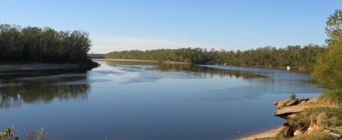
Down the Alabama River in 1814 Day five
(Continued)An amazing journal helps us visualize this historic journey down the Alabama River on August 15, 1814 – Day five of the trip.
Scroll down to read story
Over the next few days, we will follow the day by day journey of the first survey of the Alabama River which started on August 11, 1814. With this journal, we will be able to visualize the sites and experience how long this historic journey took back in 1814.
(Transcription from Transactions of the Alabama Historical Society, Volume 2, 1898)
15TH DAY
Proceeded at 5 o’clock A. M.
South 1 mile—good lands on both sides
S°. 45 W. 30 ch. good on both sides with a rocky shore on the left.
S° 75 Wt. 40 ch—Rocky shore on the left with high good lands1—Bottom on the right
West—60 ch—passed an Island to the left—a fine spring on the left shore near the head where the rocky shore ends—lands good on both sides
S°. 75 Wt. 1 Mile —good lands on both sides—a rocky shore on the left commences near the end.
N°. 75 Wt. 30 ch along a rocky shore on the left & high lands —bottom on the right.
N°. 50 Wt. 1 mile—Passed to the right of an Island—good lands on both sides
N°. 75 Wt. 60 ch. to the upper end of a high rocky bluff on the right of poor pine lands—good on both sides to the bluff— small creek from the right above the bluff
S°. 50 Wt. 20 ch along the bluff—bottom on the left—This bluff is a white rock 100 feet high2—the river not more than 80 yds wide at this place
S°. 10 Wt. 20 ch along the bluff to the head of an Island.
S°. 10 Et. 1 mile—passed to the left of an Island—a creek breaks through the bluff near the lower end—the bluff then continues about 10 ch from whence the land on the right becomes lower & better—bottom continued on the left to this point.
S°. 25 Et. 1 m 20 ch passed a short bluff, on the left, at 60 ch. good lands on both sides—Rocky on the left shore, the last 20 ch.
No. 20 Et. 30 ch to the upper end of a high bluff on the right— good lands on both sides.
S°. 60 Et. 1 mile—passed to the left of an Island—The bluff on the right ends at the Island—bottom on the left—good high lands on the right from the upper end of the Island to the end of this course.
S°. 75 Et. 1 mile—good lands on both sides—a rocky shore the last 20 ch.
East 1 m 40 ch—Rocky shore contd. on the right for 20 ch— passed to the left of an Island—a branch from the right runs through the bluff at 20 ch above the Island—good lands on both sides—spring to the left opposite the Island—Rocky banks on the left & high rich lands—A large creek3 from the left at the end of the course
S°. 55 Et. 1 mile—Rocky bluff on the left of high good land— bottom on the right—passed to the right of an Island
S°. 25 Et. 1 mile—passed to the right of an Island—good lands on both sides—A large corn field on the right, of fine corn, near the end of the distance—landed on the right and destroyed the field and took as much of the corn as the troops thought proper. It lies opposite to an encampment occupied by Col. Pearson of the North Corolina Militia in May or June last—It is of considerable extent, as will be seen by the following notes, and is situated on a valuable tract of bottom land contained in a large bend on the west side of the river—The field commences 20 ch above the place of landing—
Col. Pearsons Encampment is 10 ch below, on the opposite side, an a high bluff4 of thin pine land—It is a handsome situation overlooking the whole extent of the bend, & bottom opposite on the west
South—30 ch—The above bluff on the left & the field contd. on the right.
S°. 25 Wt. 40 ch—The bluff lower on the left—field contd. on the right—a dry creek from the left at the end of the bluff— The bluff5 commences again at the end of this distance—field ends at 15 ch.
S°. 60 Wt. 1 M 20 ch—Bluff on the left 20 ch branch on the right at 60 ch—bottom on both sides below the bluff, and the whole distance on the right.
S°.45 Wt. 1 m 60 ch good lands on both sides—small creek from the left at 40 ch. bluff land on the left at 60 ch & rocky shore— bluff low—bottom on the right—a spring to the right opposite the lower end of the bluff.
S°. 70 Wt. 2 miles— Rocky, bluff, banks on the left, but low for 60 ch to the head of an Island—passed it to the left—Bottom & spring on the right 10 ch above the Island—lands rich, and a cainey bottom on the left from above the Island, and opposite the Spring on the right—Rocky banks on the right for the last 20 ch—lands high & rich
So. 60 Wt. 40 ch to the upper end of a rocky bluff on the left— handsome creek6 from the left at the end of the distance
N°. 70 Wt. 1 m 20 ch—a bluff of thin timbered land 40 feet high, on the left—bottom on the right.
N°. 45 Wt 1 mile—Bluff continues on the left & bottom on the right—Bluff ends at 20 ch and good land on both sides the balance of this distance—A small spring on the right, opposite the lower end of the bluff.
West 30 ch along a handsome bluff to the right—a fine spring on the bluff at 15 ch—Bottom on the left.
S°. 45 Wt. 1 m 60 ch—bluff contd. bottom contd. on the left— passed to the right of an Island at 40 ch—Shoal water below the left shore the best passage—The bluff ends at 40 ch—Excellent lands below—rocky, low bluff commences on the left at 1 m 20 ch—Rich land on the bluff—branch to the left near the end of this distance.
S°. 75 Wt. 40 ch—Bluff contd. on the left and bottom on the right—pine on the bluff at the end of this distance—Spring branch on the right at 10 ch.
N°. 75 Wt. 2 m 10 ch. Bluff contd. on the left and bottom on the right—The bluff is high but it appears to consist of good land intermixed with pine—A large creek7 from the right/left 5 ch. above the end of this distance—a bluff commences at the Creek & extends down the river—on the right
S°. 80 Wt. 20 ch. along a handsome bluff on the right—bottom on the left.
S°. 50 Wt 60 ch.—Spring near the commencement on the right—bluff contd. on the right—bottom on the left—passed to the right of an Island at from 20 to 40 ch—Bluff high & piney at the end of this distance—for the last half mile it is low & rich. Spring on the right to chain above the end of this distance.
South 1 M 20 ch—High pine lands on the right—Rich bottom on the left—Pine lands recede from the river at 40 ch & leaves a narrow bottom on the right, which widens in the descent, and extends across a bend on that side at the distance of 20 ch above the end of this course—
S°. 10 Et. 30 ch.—Bottom on both sides—Creek8 on the right at the commencement
N°. 15 West—40 ch bottom on the right—High lands on the left mixed with Pine growth but appears good—Pine continues about 40 ch. after which it is nigh rich land
S°. 30 W. 2 M 40 ch—good high lands on the left—bottom on the right—A handsome creek9 from the left at 1 m 40 ch—Pine lands near the river 2 Miles, branch on the right at 1 m 60 ch—Spring on the right 15 ch above the end of this course
S°. 5 Et. 30 ch—High pine lands to the right—Bottom on the left
So 20 Et. 30 ch—Pine lands contd. on the right & bottom on the left—a small creek10 from the right
S°. 45 Et. 40 ch Pine lands contd. on the right & bottom on the left. Creek on the right at 20 ch—lands better on the right, below the creek.
S°. 55 Et. 2 M 40 ch—High lands ccntd. on the right & bottom on the left—The high lands descends to a bottom 20 ch below the commencement of this distance—Passed to the left of an Island—Improvt. & corn field on the right—at the termination of this course, commences an Elegant Red Bluff, very level on the top, and appears to contain the site of An Ancient Town or village. There appears to be from 100 to 150 acres of level, cleared land in its bounds—It affords the handsomest situation for a Town on the river, and appears to be in the neighborhood of large, and excellent, bodies of rich lands—This bluff extends for some distance down the river—It is all good land, but thinly timbered—a fine veiw of the river is enjoyed at this place, both above & below—On the opposite side is a large bend of delighful bottom land, and also another large bend on the same side of the bluff some few miles below.
South 1 M. 40 ch. contd. the whole of this distance along the red bluff—passed to the right of an Island—from 1 m 20 ,ch. to the end of the distance—several springs at the end of the distance —lands on the right a superb bottom—
N°. 10 Wt. 30 ch—Lands high & rich on both sides
S°. 45 Wt. 2 M 40 ch. Lands rich & high on both sides, mixed with scattering pines on the right.
S°. 40 Wt. 1 m 20 ch lands higher on the left and mixed with a few Pines—On the right the same as above represented— Spring to the right at 30 ch
S°. 60 W. 40 ch. Rich lands on both sides
West I mile—Rich, high, lands on both sides11—Spring branch on the left at 40 ch—a branch from the left at 60 ch.
No. 65 W. 1 m. 20 po. lands more piney, but still good on the left, rich & fine on the right—fine spring branch on the left at the end of this course.
Encamped on the left bank at 46 Miles 40 ch.
1Near the present King’s landing.
2 White’s bluff, Dallas County
3Cedar Creek.
4Militia Bluff, as appears from La Tourrette’s Maps of Ala., 1838 and 1856.
5Elm bluff
6White Oak Creek.
7“Bogue Chitto.
8“Chilatchee.
9“Pine Barren.
10“Foster’s Creek.
11″The present Bridgeport, Wilcox County, is located here.
ALABAMA FOOTPRINTS – Volume I – IV: Four Volumes in One (Volume 1-4)
SAVE – BUY ONE GET ONE FREE! The first four Alabama Footprints books (listed below) have been combined into one book, Alabama Footprints – Volume I-IV –
- ALABAMA FOOTPRINTS Exploration
- ALABAMA FOOTPRINTS Settlement
- ALABAMA FOOTPRINTS Pioneers
- ALABAMA FOOTPRINTS Confrontation
From the time of the discovery of America restless, resolute, brave, and adventurous men and women crossed oceans and the wilderness in pursuit of their destiny. Many traveled to what would become the State of Alabama. They followed the Native American trails and their entrance into this area eventually pushed out the Native Americans. Over the years, many of their stories have been lost and/or forgotten. This book (four-books-in-one) reveals the stories published in volumes I-IV of the Alabama Footprints series.


How does Patron work?
Is there a monthly charge or charge per article read?
There is a monthly charge. You can join at different levels and read all the articles on that level as long as you are a member.
This excerpt from your transaction of Down the Alabama River in 1814 Day 5 seems to be out of place. It does NOT seem like the surveyors would have “destroyed the corn field and taken corn for the troops” as it says! These were surveyors!
“S°. 25 Et. 1 mile—passed to the right of an Island—good lands on both sides—A large corn field on the right, of fine corn, near the end of the distance—landed on the right and destroyed the field and took as much of the corn as the troops thought proper. It lies opposite to an encampment occupied by Col. Pearson of the North Corolina Militia in May or June last—It is of considerable extent, as will be seen by the following notes, and is situated on a valuable tract of bottom land contained in a large bend on the west side of the river—The field commences 20 ch above the place of landing—”